|
|||
Santa Rosa is open 24 hours a day with attention to visitors available between 8:00 am and 4:30 pm
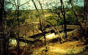 |
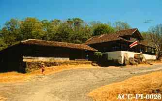
La Casona , Historical Museum of the most important heroic battle that has taken place in Costa Rica: March 20, 1856. |
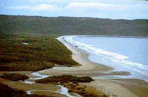
| Naranjo Beach with an extension of 7 km. It is located 12 km west of the administrative area of Santa Rosa. It is a good area for surfing and has mangroves at Estero Real and Laguna El Limbo. | |
.
|
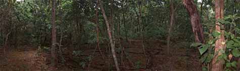
Regenerating dry forest with many species of plants and animals |
![]()
| Santa Rosa | Playa Naranjo | Estero Real |
| tables grills (cooking has to be with charcoal or natural gas) telephone drinking water showers restrooms |
tables grills (cooking has to be with charcoal or natural gas) telephone no drinking water (has to be taken from Santa Rosa) showers restrooms |
No services available in this camping area |
* Please use save water and avoid
forest fires. | ||
Monument to the Heroes, Naranjo Valley, Los Patos and Santa Elena
![]()
There are rooms at the Research Center that can be rented. Food is available with a reservation at the Dining Room. For more information or to make a reservation please call (506) 695-5598 or (506) 695-5577. Groups are welcome.
![]()
Talks and guided hikes through the Historical Museum and the Indio Desnudo Nature trail. There are also programs available for schools and groups. For more information or to make a reservation please contact the Ecotourism Program at (506) 695-5598 or (506) 695-5577.
![]()
| Name of the Trails: | Indio Desnudo |
Carbonal |
Los Patos |
| Characterization of the segment: | General public | Ecotourism, low impact | General public |
| Type of trail: | Loop | Lineal with a detour to Laguna Limbo | Lineal, natural. |
| Things to see: | Interrelation of plant and animal species common to the dry forest; archeological resources. | Dry forest, rock formations and mangroves. | Lookout to the Tiger Canyon, dry forest, bird watching, seasonal stream. |
| Total distance: | 0.8 Kms. |
6 Km. |
3 km |
| Duration: | 20 minutes |
1 hour and 30 minutes |
40 minutes |
| Highest point: | 270 m. |
3 m. |
280 m. |
| Starting point: | North of La Casona | 300 mts. before the sector caretaker, Naranjo Beach. | Road to Naranjo Beach |
| Arrival point: | Parking Area | Laguna Limbo | Tiger Canyon Lookout |
| Site description: | Dry forest with several species of plants, insects, birds and some mammals. | Onservation of dry forest plants and animals as well as mangorves and their associated species. | Dry forest and a lookout to the Tiger Canyon. Trail is mostly flat with rocky areas when crossing streams. |
| Regulations: | Stay on the trail, no extraction of animals, insects, plants or others, do not litter. | Stay on the trail, no extraction of animals, insects, plants or others, do not litter.No entrance to the mangroves outside of trail, no swimming in the stream. | Stay on the trail, no extraction of animals, insects, plants or others, do not litter, no swimming in the stream. |
Other trails:
Valle Naranjo Mirador.
Trail for all visitors with a panoramic view or Naranjo Beach. The trail
is located on dry forest and birds and other species of animals can be commonly
seen. Its distance is 1.6 km and the duration is about 30 minutes. The trail
begins 6 km west of the administration area in Santa Rosa, using the road
to Naranjo Beach.
El Pozo: This trail is a detour of the Indio Desnudo trail which leads
to an old well.
Bosque húmedo: It is located in the forest that has the same
name in Santa Rosa. This is the largest patch of primary dry forestin Santa
Rosa. Several research projects are carried out in this area.It is a good
area for bird watching.
Palo Seco: In Naranjo Beach this trail connects Naranjo with Estero
Real.
Naranjo- Nancite: Entrance trail to Nancite Beach. Nancite is a very
delicate area so the access is restricted. People interested in going to
Nancite need to request permission from the Research Center.
Tanquetas:
Old war vehicles used in the 1955 battle. It is located 3 km from the entrance
to Santa Rosa.
Santa Elena Lookout: This is a lookout that is located next to the entrance road to Santa Rosa. The Santa Elena peninsula can be seen from this spot.
![]()
You can get to Santa Rosa by public transportation
(San José-La Cruz, Liberia-La Cruz), private vehicles, or taxis.
Bus Schedules:
Liberia - La Cruz: 5:30 a.m. |
Liberia - Cuajiniquil: 5:45 a.m. |
Cuajiniquil-Liberia: 7:00 a.m. |
The Administrative Area in Santa Rosa is located
42 km north of Liberia and 27 km south of La Cruz. Cuajiniquil is located
21 km from the entrance and Potrerillos 9 km south of the entrance.
Travel time:
San José-Liberia, 4 hours
Liberia- Santa Rosa, 40 minutes
![]()
| Gas stations | Distribuidora García Venegas- La Cruz, 27 Km.
Estación de Servicio Valdelomar- Liberia, 42 Km. Estación de Servicio Texaco. Liberia, 42 Km. |
| Pharmacy | Farmacia Auxiliadora, Liberia 42 Km. |
| Supermarkets | Palí, Liberia, 42 Km. Coopecompro. Liberia, 42 Km. |
| Hospital | Enrique Baltodano, Liberia; 42 Km. |
| Places to stay | Hotel Los Boyeros- Liberia, 42 Km. Santa Clara Lodge Quebrada Grande, 20 Km. Amalia's Inn- La Cruz, 27 Km. Los Inocentes Lodge, 36 Km. |
| Places to eat | Restaurante Ehecalt- Potrerillos, 9 Km. Restaurante Mata de Caña Quebrada Grande, 16 Km. Restaurante La Orquidea- La Cruz, 27 Km. |
![]()
.